Showing posts with label petroglyph. Show all posts

Monday, January 9, 2012

A Trip to Cedar Mesa, UT

A brief intermission from the winter and snow scenes in CO to bring you a southern Utah landscape with large rocks and a road...

In The Valley of the Gods
9x18 inches - pastel on construction paper
© 2012, S.Johnson
So, this is the painting that would have been my plein air painting, if the timing had been different.  I started it on Friday and it languished on my easel for a few days.  Unlike the recent snow scenes I've been doing, this one did not come together quickly.

On Thursday morning, we headed out for one of our favorite destinations in southern Utah:  Comb Ridge and Butler Wash.  The plan was to hike to a few ruins and petroglyph sites listed in a guidebook and then find a good location in the early afternoon where I could do a plein air painting.

Alas, it didn't happen.  The guidebook we brought to find the particular ruins (called Double Stack ruin) was so vague in its description of the route that we never found them.   Trying to find such hidden archaelogical treasures is really difficult without a GPS and reliable beta.  So, we spent far longer hiking up Comb Ridge than we'd planned, and by then, it was too late to start any painting.

But, that was a minor setback in the scheme of the trip.  Instead of risking more disappointments from said guidebook, we decided to head west along the highway and check out the BLM area known as Valley of the Gods.  Not to be confused with the Garden of the Gods, which is near Colorado Springs, this area forms what is essentially the southern edge of the Cedar Mesa.  A 17-mile loop drive on a dirt road takes you through the valley and past countless buttes, spires and amazing balanced rock formations.

If these eroded structures look similar to Monument Valley, that's because it is about 25 miles to the southwest.  Probably the same sedimentary rock, but I cannot confirm this.

Anyway, here are a few of the photos from the hike up Butler Wash.

First stop is the Wolfman petroglyph panel* - a short hike takes you to these remarkable examples of rock art.  They can be seen from several hundred feet away:

You would need a ladder to reach these.  Aren't these designs beautiful?  So precise and symmetrical - these were artists who were clearly skilled and took pride in their work.  I've often thought about how fascinating it would be to travel back 1400 years and meet the creators.

Another section with a central animal figure (it looks like an owl to me), a botanical design and maybe a staff of some sort?  

Why I love abstract art:  interpretation is up to the viewer
This makes me smile; I like to think this figure is doing a Happy Dance
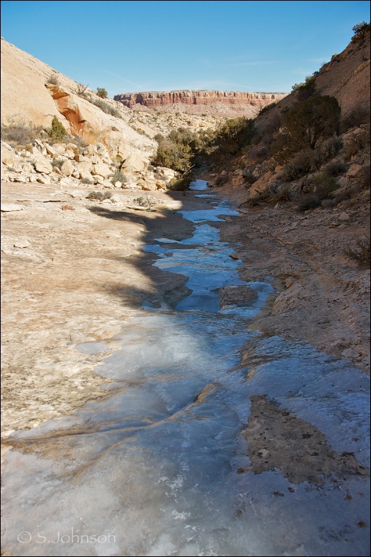

Next stop: a side canyon creek in Comb Ridge...frozen solid
  No ruins to be found!

Obligatory abstract image:  detail of ice from creek
Trapped air or crystal formation?  I'm not sure, but I love the patterns created.


*Editorial note:  readers will be disappointed if visiting the Wolfman petroglyph to see that doesn't look quite like the photo - several bullet holes from vandals deface the surrounding rock facade and some of the actual art.  Sad, but true.  I opted to edit them out as best I could, since they are ugly and shouldn't be there to begin with.

Tuesday, April 5, 2011

Butler Wash pastels - ACEO

I can't get the Utah trip out of my head, so I am running off with it in color...

The Wash
2.5 x 3.5"
pastel on Strathmore

Tank Mesa
SOLD

Road to Bluff

Sun-Kissed Cliffs
SOLD

All from photos taken during the Butler Wash-Cedar Mesa trip.   Not shown in sequential order, but in order of my favorites, and also in the reverse order painted.  I'm pretty sure I'll revisit these in larger sizes and probably part of another series based on this trip...

I have many photos taken of hikes along side canyons and washes; I could do an entire series of them, and I have painted them a few times before in my Four Corners Roadtrip series:  Turning Point, Along the Wash, and Pathways are some examples.   This is a tributary to Butler Wash that we crossed on our way to the Procession Panel petroglyph (see previous post for photos).    

Tank Mesa is to the east along the Butler Wash road.  The cliffs, slopes and basin are quintessential southern Utah canyon country elements.  

Hwy 163 leading to Bluff, UT follows the San Juan river; the line of cottonwoods is a give-away that water is nearby.  A mesa on the distal side of the river casts shadows, and the pale sandstone lifts of Comb Ridge are seen in the distance.  

----------

Photos from Monarch Cave ruins, our second hike in Butler Wash on Friday.  I was glad I brought the tripod along for this 3 mile RT hike:

The ruins in the alcove.  Look at those amazing patterns the desert varnish forms!  One of my favorite photos of the entire trip.  

Approaching the entrance

From the other side of the canyon

Broken metate (corn grinding stone), pottery sherds and corncob...all 700-1000 years old.  You won't see these lying around at Mesa Verde.  

Some of the many examples of rock art at Monarch Cave; these were about the same size as my hand.


Art of the ancients: a trip to Comb Ridge

"Towards Monarch Cave"
9x12 - graphite on paper

Finally back, sort of...a cold that decided to kick in on the day of our trip managed to take the wind out of my sails as far as getting much of anything done in my studio since our return, although I did manage to go through and edit the 300+ photos I took.

Otherwise, I did some pretty bad charcoal sketches from some of the photos yesterday, and then today, this quick pencil sketch. It probably showcases my rather weak drawing skills more than anything, but it was all I was able to muster between the headache and sinus pain that has plagued me for the past 2 days.

Back to the trip.  In a word, it was amazing.   I absolutely love this land.   As we drive and hike through the washes and along the edges of side canyons, I find myself never wanting to leave.  

Butler Wash Road & Comb Ridge
We come to explore the landscape itself, but also to experience the culture of those that inhabited the region since before the birth of Christ until the 13th century.  Evidence of their presence - cliff dwellings and rock art - is found all over the area.

Comb Ridge, our destination on Friday, is a large, 120-mile long monocline that begins about 10 miles west of Blanding, UT and runs in a north-south direction, then turning east-west before terminating near the Navajo town of Kayenta.   A photo of the southern part of Comb Ridge east of Kayenta may be seen here.

Trail to Procession petroglyph panel

A non-descript dirt road just west of Bluff, UT, heads north off of Hwy 163.  It has a small blue-and-white road marker, but otherwise, there is no indication of what it leads to.  Unlike Mesa Verde, where everything is paved and made available to the masses,  Butler Wash is a completely different experience, which is its appeal.  You have to work to get there.      

Small, unmarked spur roads are the only indication of where to stop.  Trails are also unmarked, save for the periodic BLM sign reminding you of the cultural significance of the area and to not take or disturb anything.   

View of the monocline from the trail
The hikes are pretty short - generally around a mile or so - to each of the destinations.  However, they aren't casual strolls; the trail to the Procession panel went up and down some steep slickrock, with about 600' in elevation gain.  Going to the top of the Comb and looking over the rim like we did added an extra 200' or so to that.  


Our first stop was the large section of petroglyphs known as the "Procession Panel".  Named for the 179 human figures and several animals painstakingly pecked into the sandstone face, it is a remarkable piece of art in its own right:

Procession panel panorama
[click on photo to see larger image]


The lighting was far from ideal for photography, but what are you going to do?  Take photos anyway.  It was fascinating to look at the composition of the panel:  numerous small figures converge from three directions to a circle.  Some of the human figures appear to be elders or perhaps shaman, carrying curved staffs and positioned between the smaller figures:

And, there is this group of 5 that appear to be carrying torches:


Clearly, some artisan(s) went to great effort to create this panel.   It is located a few miles in either direction from the nearest cliff dwelling, far out of the way.  So, what does it mean?  Does it symbolize the mass exodus of the people from the region to the south?  A meeting of clans?  Does each figure represent an actual individual?  One can't help but to ponder such questions while looking at the panel.  


Another 1/3 of a mile past the panel, and you come to the edge of the monocline.  Some hikers we passed told us of Moki steps (depressions carved into the rock), but we didn't look for them.  Instead, we got a panoramic view of Cedar Mesa to the west, Monument Valley to the south and Comb Wash about 1000' below.
Sleeping Ute Mountain framed by the walls of the adjacent side canyon on the way back down:
-------

I'll add more photos from the trip with brief descriptions in later posts, following the daily paintings.  With luck, that will be tomorrow.  


Monday, December 27, 2010

By the Hand of Man - photoessay

From the archives....

Here is a collection of photos taken in various locations, showing historic and prehistorical marks of humans upon the land.

 Newspaper Rock 

This amazing petroglyph panel spans 2000 years in its creation.  Location:  near Canyonlands NP, southeastern Utah.
Anthropomorph pictograph in red

Found on the wall of a protected alcove formed from sandstone, this was the most elaborate of the designs.  Location:  Canyonlands NP.
Roadside Granery

Likely built by the Fremont in the 8th or 9th century, I believe, these small mud-and-stone structures were designed to store and protect grain and corn from damage from pests and weather, as the nomadic people traveled from season to season.


Historical hunt(?) scene

A herd of bighorn sheep are shown surrounded by riders on horseback, dating these petroglyphs to at least the mid to late 16th century.    They are skillfully executed.

Location:  along trail to Delicate Arch, Arches NP.


 Frog/lizard figures and.....?

What is that figure on the lower right side supposed to be?  This panel predates Picasso, suggesting that Cubism was perhaps invented by the Navajo living or passing through Chaco Canyon, NM ;).  It is believed to post-date the Anasazi who lived in the area in the 9th through 12th century, however.
Another Chaco Canyon panel

Birds and animal quadrupeds are seen, along with a few sun spirals.  These panels are unreachable except with a ladder, suggesting that the lower rock the artist(s) used has fallen away.

Tuesday, April 13, 2010

Rock Art Series - Kings Canyon Wash, SNP

About two weeks ago, I went on a hike up Wasson Peak, located in Saguaro National Park west.  The trailhead, located right across the road from the AZ Sonoran Desert Museum, is 3.5 miles one way.  The trail crosses over a large wash on the southern slope of the mountains.  On the way back, I was struck by some large clumps of grasses forming a bright silhouette in the afternoon sun, so I jumped down to take some photos.  As I looked to the rocks on the side of the wash, my eye quickly caught some petroglyphs.  Additional inspection revealed multiple panels on both sides of the wash.

I found out later this is one of the 8 major sites located in SNP west whose location is not made public.  Reason:  vandalism and theft of the panels.  It is disheartening, and quite frankly, infuriating,  to find damage to these cultural resources.  Evidence of recent graffiti on adjacent rocks, using crayons or chalk, was also present.

Here is a selection of art from this site:

Snake form and mixed design


Hidden Sun
Easily overlooked, this design is simple but elegant

Snakes in Rock and Shadow
At least three petroglyphs have been pecked into the rock; was it just coincidence that the shadow cast by adjacent foliage produces a snake-like form that almost parallels the rock art?  Probably, but regardless, it makes an interesting mix.


Mixed figures
Curved and linear abstract shapes are seen on the front face of the rock, while additional work can be seen on the left face as well.

Thursday, April 1, 2010

Rock Art Series - San Pedro River #2

Here is the second set of rock art from the San Pedro River.  These panels, approximately 1/4 mile north and slightly west of the previous, are located about 200 meters from the San Pedro itself.  They are part of a huge rock outcrop area, and I suspect there were probably several others located on rocks above and out of view of these main petroglyphs.  Due to weather conditions, a weary dog, and the presence of numerous thorny shrubs, such as catclaw acacia, that managed to shred exposed areas of my arms and legs, I opted not to explore further than I did.

Solo Deer

Three's a Crowd
These charming stick people are a common motif of Hohokam rock art.  

Concentric Circles, joined
These abstract designs are thought to possibly be astronomical or possibly a shamanistic "vision" in nature.   An enigmatic image, to be sure.

Snake and multi-limbed figure (centipede?)
These look to be done at different times by different artists, based on the line forms.  They may have been done hundreds of years apart, in fact.

Connected boxes
The large panel of connected box shapes is referred to as a "pipette" by the author of the South Mtn. rock art book.  These occur frequently in the South Mountains, which are about 200 miles away.  

References and further reading on the Hohokam, rock art, and other indigenous peoples of AZ:

Bostwick, Todd W.  Landscape of the Spirits:  Hohokam Rock Art at South Mountain Park.  University of AZ Press, 2002.

Reid, James Jefferson.  The Archaeology of Ancient Arizona.  University of AZ Press, 1997

Tuesday, March 30, 2010

Rock Art Series - San Pedro River

Ever since I was a kid, I've had a fascination with rock art made by prehistoric cultures.  I was probably first exposed to it on one of our many camping trips through the southwest.  Many, if not all, of the ancient peoples living in the southwest created images on the most durable and readily available canvas:  rocks.   Archaelogists have studied, described and attempted to explain the meaning of the images painted or pecked into the rocks, but ultimately, much of it remains an enigma.

In the southern region of AZ, the most well-known prehistoric culture inhabiting the area around Phoenix, Tucson and as far east as the Tombstone area were the Hohokam.  They were an agrarian culture, with their villages located near water sources now known as the Gila, Salt and San Pedro rivers, and probably lived in the area for perhaps 500-700 years, around 1000 AD.  It is a testament to their resourcefulness, intelligence, toughness and respect for the land that they were able to survive for so long in such a harsh and unforgiving climate.  For reasons unknown, they disappeared before history began (read:  the Coronado expedition in the mid 16th century).  Their living descendants may be the native people that were occupying the land during Coronado's travels - the Tohono O'Odham (formerly known as the Pima and Papago).

In addition to finding Hohokam village ruins throughout the region, there are numerous areas of rock art panels found.  What is interesting is that they generally were not found in the same locations as the villages.  I recently finished reading a book on the Hohokam rock art of South Mtn., located in Phoenix, which is at least a few miles away from the Gila river.  Hundreds of panels are present in these mountains, usually near drainages or other water sources.

Prior to and after reading this wonderful book (I will have to provide the author/title in a later post), I've been visiting sites of rock art, and of course, taking lots of photos.  The book provided some useful terms  used to describe the images, so I'll be using those in my descriptions as well.

A quick primer on rock art:  "pictograph" - refers to images painted onto the surface of a rock, as with the Mogollon rock art panel shown in the Council Rocks post.  "Petroglyph" refers to images actually tapped, or pecked, onto the surface of the rock, using a set of rock tools (hammer and chisel).  The superficial, patinated layer of rock is removed, exposing the pale underlying rock.  The degree of repatination (due to the combined effects of water, sun and time interacting with the mineral layers of the rock) can help date the petroglyph.

Whatever the reason the Hohokam created these delightful and fascinating abstract designs may never be known, but art is art, so I am pleased to be able to share the work of artists long since gone, but whose spirit remains with us generations later.  Enjoy!

Location:  adjacent to the San Pedro River, off of Charleston Rd., ~10 miles southwest of Tombstone.  These panels were on an outcropping of rocks along the trail, perhaps 1/4 a mile east of the river.

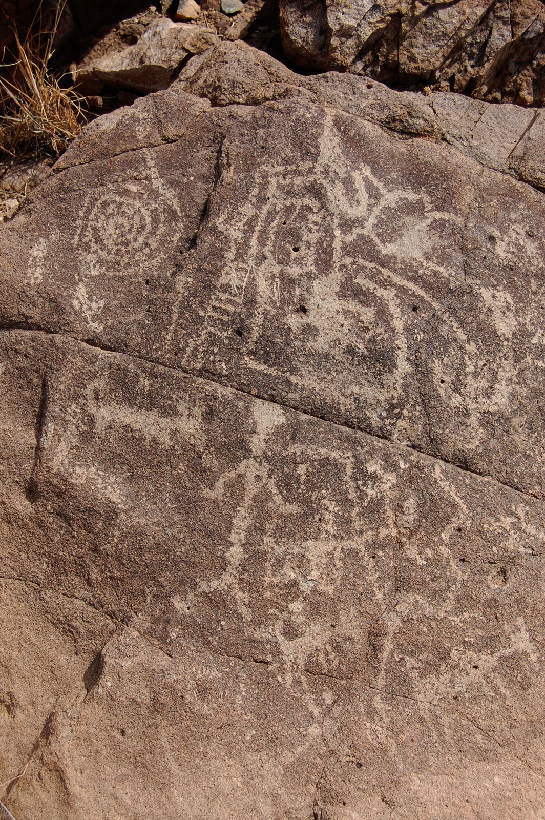
Mixed panel
A spiral - a common Hohokam design - is seen to the upper left.  A series of connected, curving lines and shapes, along with a linear ladder-type design are seen to the right.  Below the rock fissure a few anthropomorphs (human-shaped), quadrupeds (generic four-legged animals) and a snake form are seen, and the snake appears to be connected to a cross and other curved lines.


Mixed panel, detail
Spirals are thought to possibly represent visions or dreams by shamans.


Mixed panel #2
More anthropomorphs, and what appear to be either faces with headdress or prints (bear?) are seen, along with some anthropomorphs and a circled cross - another common motif seen.


Sun design, quadruped and lizard(?)
Quadruped is either a bighorn sheep or deer; the Hohokam typically gave their ungulate forms long, upright tails and horns that often pointed in the wrong direction.


Unknown animal form
This could be a reptile with toe detail.  The branching of the tail could be demonstrating movement.  The design below looks as if it were rubbed out.  There is something that looks like a "crossed ribbon" design  (looks almost just like the pink breast cancer ribbon design on the flash drive stick I'm using now!)


Vertical panel
This block/ladder pattern makes use of the orientation of the rock, and originates with some unidentifiable figures above.   Given that the Hohokam were not cliff dwellers like the Anasazi, the image is probably not a ladder.  


Related Posts Plugin for WordPress, Blogger...