Showing posts with label sunrise. Show all posts

Saturday, July 2, 2011

Roadside Cliff Shadows - plein air, San Juan panoramas

My other painting done on the trip - the not-best for last, I guess you could say:

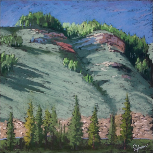
Roadside Cliff Shadows
12x12 inches - black Strathmore

This piece was done in the late afternoon on day one of our trip, a couple of hours after we got back from the first trip to the Lizard Head area.  It's from the campground, from a small meadow near some sites where those huge motorhomes can fit, complete with plenty of space for their satellite dishes...  

My intent was to make it more abstract in terms of colors and shape.   The small stands of aspen on both the top of the cliff and along its slopes were just so appealing (see photo from previous post of the basic view).  Watching the light and shadows change throughout the day on these cliffs and the dividing ravine was so interesting to me.  That, and the presence of both warm and cool shadows on the exposed sedimentary rock, which I believe is Cretaceous period Dakota sandstone.  

I didn't finish the bottom 1/4 of the painting on site, so yesterday, I sat down and tried to resolve it a bit.  I decided to add the road to perhaps help explain the abrupt cut into the cliff.  The roadcut area looks just as unpleasing and out of place in my painting as it does in life, so I guess maybe I shouldn't harsh on it too much.  

At any rate, it was just pleasant to sit in the shade of some large trees and paint it.  Wayne brought out his chair, book and a beer and joined me.  The mosquitos brought their A-game, but are no match against loose, full length sleeves and pants.  

Now, that that the token artwork is out of the way, I can share some of my not-so-secret photography obsessions:  panoramas, or "panos" for short.   Shooting panos can be addictive, and with the advent of high-tech stitching software like the Double Take program I use, it's pretty easy and fun.  Use of manual settings on the camera and a tripod is ideal for panos, but that is really impractical for me 90% of the time since I never carry a tripod on hikes.  Hand-held shots can work fine with practice.

I actually have two Picasa albums devoted to panoramas:  one for Grand Canyon shots, and the other for everything else; some I've posted to the blog in the past, but most have never been shared.   Have a look.  

First up - a view from the East Fork trail on Monday afternoon [click on the photos to see a larger size]:

San Miguels from East Fork trail
3-part landscape-oriented, hand-held

During our hike, I mused to Wayne about how stunning this would be as a sunrise shot to catch the alpenglow on the snow on the east face of the mountain.  What originally seemed like something only a hard-core photographer would do gradually came to be more doable as I considered it.  The main issue is that, despite my desires to be so, I'm not a morning person.

Nonetheless, we discussed it, and decided to give it a go if we got up early enough and could get motivated to drag out of the warm sleeping bag.  Wayne, bless his heart, is always accommodating to my silly artistic whims, as inconvenient as they may be.  We made it happen...sort of:

San Miguels in Morning Light - 5:50 a.m.
3-part landscape-oriented, tripod-mount

I impressed myself by hiking 3/4 of a mile at 5:40 in the morning just to get some photos, and with my tripod.  Perhaps there is hope for me to be one of those "hard core" photographic types after all.

Here's the alpenglow shot from the trailhead, shot at 5:35 a.m.:


Here is a shot a few minutes later, showing the light hitting the hillside:

Hillside Morning and the San Miguels
2-part tripod-mount

After we packed up our camp and headed out up Hwy 145 to spend the next few hours taking in the scenic beauty of the rest of the San Juan Skyway drive, a stop at Trout Lake was in order:

Morning at Trout Lake
4-part landscape-oriented, hand-held

Notice the golden shimmer across the water?  It's pollen, although I'm not sure of its source.  While these  west-facing mountains generally look better in late afternoon light, this photo isn't so bad.

After a quick stop in Telluride for some coffee (and noting several plein air painters already out painting for the Telluride Plein Air Festival that started the same day), we headed along Hwy 62 towards the Dallas Divide.  This geographic and geological divide separates the volcanic San Juan mountains from the Uncompahgre uplift and plateau to the north and east.  

San Juans along the Dallas Divide
2-part landscape-oriented, hand-held
Mt. Sneffels is the highest peak to the left, at 14,150'.  Telluride is on the other side of the range

Here's another single shot of the Mt. Sneffels range, as seen from famous designer and preppy clothing mogul Ralph Lauren's ranch (Double RL Ranch):

This could have been your view...if you'd come up with the idea to embroidery a polo player logo onto clothing

No more panos, but here are a couple of shots from the remainder of the trip:

Close-up of the Uncompahgre Gorge with the river of the same name located in Ouray.  In the winter, this is used as an ice park by climbers.  Crazy, you say?  I agree.

A view of the valley overlooking the town of Ouray.  Some monsoon-type clouds add to the view.

After leaving Ouray, the road climbs up over Red Mountain Pass, then drops down into the old mining town of Silverton, following Mineral Creek part of the way.  From there, it's back to Durango, heading over Molas Pass, Coal Bank Hill, and through the scenic Animas River valley.  

A truly glorious drive, and sort of the obligatory "must do" trip for visitors to Durango that Disneyworld is to Orlando.  Only this is a far, far better way to spend the day.


Monday, December 6, 2010

"Teec Nos Pos" - #43 in FC-CP series

In my road trip travels over the years, I've always been interested (and often amused) by the ways in which towns announce their presence to passers-by on the highways and interstates.  In the northeast, it ranges from a simple DOT green-and-white sign along the side of the interstate to a hand-crafted and painted wooden sign "Welcome to _____" as you enter the quaint town or village on a 2-lane road.

In the midwest, I saw town names painted on the sides of barns, and Adair, Iowa, has the town name with a huge smiley face on one of their water towers.

A uniquely western trend, however, is the placement of white rocks on the side of a mountain, hill, or cliff with the first letter of the town.  As a kid, I found this neat, and I guess I still do.  In Tucson, where I went to college, it was "A" Mountain, and was maintained by U of A students.  Prescott, where I spent early childhood and part of the first decade of '00, has its "P" on the mountain.

So, when I saw the full name of the small community of Teec Nos Pos on the slope of a small mesa, I knew I had to paint it.  The name means "circle of cottonwoods" in Navajo, a typically descriptive term of the area.  It is here that the highway heads in a more northeastern direction, and the Four Corners monument is a few miles away.

"Teec Nos Pos"
9x12
oil on panel

Painted from a composite of two photos, I completed this rather quickly in one session yesterday.  However, I had to wait until today before adding the lettering, using a tiny liner brush.  I'm also really digging painting on these oil-primed panels I made. 

And here are two photos from this morning's sunrise.  At this time of the year, the magical light is right around 7 a.m., just when I'm getting up.  What a great way to start the day!

The pink glow on the La Platas to the northwest was unreal, and sadly, not captured as well as I'd hoped in this photo.


Sunday, December 5, 2010

Turning Point - #42 in FC-CP series

Washes, drainages, draws, and watersheds - all terms applied to areas of water accumulation and flow in the west and southwest, and often imply water as an ephemeral presence.  Driving across the deserts and plateau country, one notices the meandering paths that washes take, seldom direct and never in a hurry.

Number 42 in the series is such a wash, one of the countless and un-named that carry water from mountains and mesas to the south along our drive.  I was drawn to this image for both the curve and somewhat ambiguous path of the wash and its bright sandy bed and the small outcropping of crumbling sandstone that is directing the path.  It has contrasts in color, line, texture and shape that appealed to me on many levels.

Turning Point
11x14
oil on canvas

After tinkering with it a bit over 2 days, I'm finally satisfied with the result.  As I approach the reference photos for painting sources, I do often make small adjustments:  eliminating distracting elements or shifting of others to a more harmonious position.  I also try to be mindful of things like intervals, such as the shrub locations, shapes and colors.  I don't obsess about the "rule of thirds" or making sure there is a specific focal point, but rather an "area of interest", and making sure there is nothing that leads the viewer out of the painting.   In this case, the large shrub acts as both a point of interest and blocks the path out of the painting.   

I've seen artists get overly analytical about their paintings in terms of these principles, and the paintings sometimes look contrived and formulaic.  So, while it's important to understand the rules and why they exist, I admit that I often go with my gut reaction as to what to paint - images that trigger my emotions on some level and take me back to the moment I was there and the feelings the view inspired.  That is what I hope to share with viewers in some way.

And, here are two sunrise photos from yesterday morning:


Friday, September 10, 2010

Labor Day trip to north rim of GCNP- Part II: the Canyon

The north rim of the Grand Canyon differs from the south rim in several ways.  For one thing, only about 10% of the visitors to GCNP go to the north rim,  making it much less congested.  The elevation is also about 1000' higher than the south rim, resulting in views that allow one to almost look down upon the distal horizon.  The reason for this is the series of faults and the east Kaibab monocline that produced the Canyon:  the earth rose and the water cut a channel through the sedimentary layers along the fault line.  Side canyons formed as water found its way to lower points, causing more rapid erosion.  There probably remains some debate amongst geologists, but I believe it is generally accepted that the Canyon itself is about 5-6 million years in age.   It averages 10 miles across,  a mile deep, and is 277 miles in length.  The rocks that form it span in age from 245-1700 million years [1.7 billion].    Simply put, the magnitude and scope make it hard not to be impressed.

We arrived at Timp Pt. around 5:30, AZ time, on Friday afternoon.  Monsoon season was either over or was on a brief hiatus, so there were no concerns about rain.  In fact, it was a cloudless day for most of the drive, which is always less than optimal when hoping to get some great photos.   However, clouds had appeared to the west as we drove, and some lingered over the canyon itself that evening.

We secured a campsite, but after taking a walk down the road, discovered that the next site over actually had a better view (a plus for me, as I had planned to paint, and wasn't keen on hauling my pastels and easel out 1/2 mile to the other vista we found).  So, we relocated our gear, just as the sun was setting.

Sunset at Timp Pt.

This was the view about 20' from our campsite.   The view is to the south and slightly west.  Not a high-drama sunset that can often be seen at the south rim due to the direction of the light, but this instills a sense of calm, I think.  There was a lot of haze in the Canyon, either from Las Vegas or dust particulates from the dry air and wind.


Mid-morning light
Because of the haze and lack of clouds, I didn't end up taking that many photos, or at least with the intent that they turn out "photo-worthy".    But,  you can't come to the Grand Canyon and not take at least some photos to remember the stay, so here is one.

The western edge of Powell Plateau is seen to the left, connected by a saddle to Steamboat Mtn.  The Colorado river is on the distal side, running between the sets of reddish cliff sets.  The Havasupi reservation is on the south rim.

Saturday was "do your own thing" day; Wayne went on a hike along the Rainbow Rim trail, Dave and Eva took their mountain bikes along the same trail, and I attempted to paint.  I had earlier cased out the prime location for setting up an easel, and thought I'd be able to do at least a few paintings.  But, it ended up being quite hot, and instead of setting up the easel in the sun, I pulled a chair over and painted in the shade.  Because it was so difficult for me to narrow down a composition sitting there, I ended up using a photo and sketching the basic shapes in from the thumbnail view, and then working from the view.

The painting isn't posted because it got pretty significantly smeared when it was taken out of the car after we got back.  I may try to fix it, but haven't had the desire to thus far.  It suffered from the limitations of my pastel palette, although as with the previous plein air paintings, it was a valuable process nonetheless.

On Sunday, our group decided to go hike along a different portion of the Rainbow Rim trail.  This trail, which starts at Timp Pt. and ends at Parissawampitts Pt., is 18 miles in length, one way.  It's a multi-use single track trail open to any non-motorized form of transportation.  It follows the contour of the rim, much of which requires long cut-backs through the forest in order to cross the drainages to the side canyons before they become impassable cliffs...

We drove out to North Timp Pt., and before we knew it, we'd decided to go all the way to Locust Pt., 6.5 miles away.  None of us were planning such an ambitious hike, but given that the trail was essentially level with minor changes in elevation, and in shade much of the way, it didn't take on Death March proportions.

View approaching Locust Pt.


We had to hike 6 miles through the forest before the rim came into view again.  N. Timp Pt. is immediately to the left.  Steamboat Mtn. is above it to the left.
The gray-white cliff formation is Coconino sandstone, which overlays the dark red Hermit formation.  In this part of the canyon, the Hermit is frequently covered with vegetation.

Eva, Dave and Wayne at Locust Pt.
Everyone is happy that we made it and can now turn around and hike the 6.5 miles back to the car.  North Timp Pt, and the location of our car, is right above Eva's right shoulder.

It's easy to underestimate distances and scale in the Canyon; it is probably less than a mile as the crow flies, but impossible to get to without a hike of several miles.


The hike back:  Ponderosas and a view
I opted to take photos of the trail on the way back.  Better lighting and a more leisurely pace.

This is looking back towards Locust Pt., showing the hint of the rim ahead, and the beautiful ponderosa pines.


Through the aspens...

This is heading back to N. Timp.  We are still on the north side of the drainage heading east, well before cutting back across the draw.  The trail heads through this lovely stand of aspen before dropping down on its approach towards the cutback part of the trail.


...and a grassy meadow
After the trail drops down from the N. Timp Pt. ridge, it enters the draw - a beautiful grassy meadow with aspen, fir and pine.


After another ~3 1/2 miles or so, we are back at N. Timp Pt.  Dave and Eva had powered through the hike without stopping, having been a bit low on water.  It was after 4 p.m., and the light was turning the Canyon into a series of silhouetted shapes, ever fading as they disappeared into the western horizon.


N. Timp Pt. pano

What is car camping with friends all about?  Hikes like these, sitting around a campfire each night after a hot meal, and of course, drinking beer.  No one came unprepared, and especially after a 13 mile hike, cold beer sounded like an excellent idea.    Here is the informal "beer tree" or "beer shrine" that was going at the campsite.  It looks rather white trash until you realize there is no Coors,  Old Milwaukee, or Budweiser, or cans - just Ska microbrews and some Sam Adams and Full Sail Pale Ale:  the Good Stuff.  The spontaneous placement of the bottles in this common location appealed to our artistic aesthetics (and sense of humor), so it had to be captured on digital film before the bottles were collected prior to our departure.  


Sunrise at Timp Pt.


Due in part to both early morning insomnia and my motivation to actually get up and out of the tent for the 1/2 mile walk down a spur trail off of the Rainbow Rim trail to the actual Timp Pt, I did manage some sunrise photos.

There is something special about sitting on the rim of the Canyon before sunrise and watching as those first rays hit the far edges of the rim and then sweep across the depths, casting shadows here and there on the buttes and canyons.  It was quiet, save for some small birds that were diving and cavorting through the otherwise still air.   As much as I'd like to be, I'm not much of a morning person.  So, being able to actually get up and watch the sunrise (around 5:45 a.m.) was a treat.  Dave, an accomplished photographer, had gotten up the morning before to shoot sunrise photos, so that also helped motivate me to get up.

Light across points and plateaus
In this telephoto view to the southeast, Stina Pt. remains in shadow, while the upper sandstone cliffs of Powell Plateau receive early morning light.  A small, distal triangle of the south rim falls between. The elevation drop between north rim (of which Powell Plateau is part of) and the south rim is evident in this photo.


So, after a wonderful weekend enjoying the tranquil beauty of the north rim with friends, we packed up and headed home on Monday morning.

Hmm...just realized it is Friday already!  Sky Friday posts to resume next week.

Friday, February 19, 2010

Sky Friday

After missing last week's Sky Friday post, we're back on track. These photos are from the January 17 sunrise taken from the motel courtyard.  They are shown in the sequence taken.  All shots are hand-held; it's way too early and cold to be fiddling with a tripod:
First view, facing east
Multiple layers of clouds reflect different wavelengths based on their position in the sky.

Facing west and skyward
The tip of the tree gives an indication of the position of these altocumulus clouds.

Another view looking west
The clouds form wavy peach-colored streamers across the sky

Skyward eastern view
With no land to anchor them, these clouds take on an abstract form

Final view to the east
The clouds have continued their transformation and now appear to have turned into a layer of altostratus, giving a diffuse glow of color to the sky.

I will certainly miss these skies when I return to CT.

Tuesday, February 9, 2010

Stormy Sunrise

I wouldn't necessarily describe myself as a morning person, although I wish I was, because I do love the peace and quiet of the early morning.  And, of course, watching the sun rise.   Suffering from not infrequent episodes of early morning insomnia usually means I miss a lot of sunrises because I've fallen back asleep by that time.  However, sometimes, it can work in my favor.

Yesterday morning was such a day.  I found myself awake at 5 a.m., and wasn't able to fall back to sleep.  Around 6:30 a.m., around the time that the sky is starting to show the first signs of light, I got up and immediately looked out the window to the east:  clouds - hazzah!  Before I could talk myself into getting back into the warm bed, I threw on some warm clothes, grabbed my camera gear, and headed out the door.  It was quite chilly out, although that is of course a relative thing.  Being Sunday morning, the town was still asleep, and I only saw a few other cars the entire time I was out.  It was glorious.

I had assumed that a prime location for sunrise photos would be along Hwy 80, towards Douglas.  So, I headed out there.  The sky above Bisbee was blanketed in a heavy layer of low-lying stratocumulus clouds, which generally kill any hope of an attractive sunrise.  However, to the east, there was already some pink hitting the underside of distal clouds, and there were patches of open sky, so there was definitely potential.

Once I got east of the hills of the Mules and could see the distal horizon, I realized that I was too far north for an optimal position.  But, there was some color in the sky, so I got a few shots.  Figuring since I was already out, I'd head out towards the airport and see how the sun position was for future reference.  I was delighted to see that I was, in fact, not too late to arrive on some more sunrise color.

I think what makes these particular images interesting isn't so much the dazzling colors but the complexity of the clouds.  There are low, intermediate and high level clouds, some close and others many miles away.  Each catch the sun's rays at different levels, thus producing different colors and effects. 

While it didn't rain during my outing, it did begin to sprinkle as I came home, and we did get a bit of rain later in the afternoon.  This morning when I woke up (well after sunrise), there wasn't a cloud in the sky. 

I hope you enjoy this latest sunrise set:

From Double Adobe Rd
This was the single keeper shot from the drive down Hwy 80.  The lower level stratocumulus cloud layer isn't bringing anything to the table here, but the upper level clouds offer a nice splash of pink.

Transition
Taken from the second location south of town, that same stratocumulus layer now gives a beautiful glow of colors while some bright yellow gives the location of the sun.

Depth Perception
A seperate stratocumulus to the south retains its dark blue-grey color, unlike the smaller cloud fragments.  The higher level altostratus clouds in the distance offer a pleasing range of muted oranges, muaves and blue-greys.
Catching the Light
Turning 90 degrees to the north revealed these beautiful colors and shadows on the eastern hills of the Mules.  A tiny window of blue sky peeks through the stratus clouds here.
Fair Skies to the East
The distal mountains take on the same colors seen in the clouds over them.  The nearby stratocumulus is really calling the shots in this photo, however.

Friday, February 5, 2010

Sky Friday - a new weekly series

Over the two and a half months that I've been here in southern AZ, I've developed an ever-increasing number of sky/cloud photos. Many are taken from the courtyard area of the Jonquil, and others are taken in various random times I happen to have my camera with me and see something unique going on in the sky.

Probably the most telling sign I've completely geeked out over clouds is that I purchased a copy of the Cloudspotters Guide: The Science, History and Culture of Clouds. It's written by Gaven Pretor-Pinney, who is the founder of the Cloud Appreciation Society. It's a fascinating and well-written book, infused with the author's dry sense of humor (he's British, so there you go).

Anyway, the combination of these things made me think that it would be fun to do a weekly post of skies. These would probably be a few random photos, vs. the usual sets that I have been posting. I'll include information on the clouds, if relevant, or just a brief comment about the time and location.

I may do this in lieu of or in addition to non-photo, non-sky art posts as well. I hope everyone enjoys these, and as usual, fellow artists are welcome to use them for reference material for painting.

So, here are a few random sky photos for this Friday:
Sunrise, Jan 17th - cirrus clouds
location:  Jonquil courtyard
Late afternoon on the hillside
location:  behind Jonquil motel
This tree makes it into many of my photos, and adds a fun contrast to the cumulus clouds.  The upper whispy clouds are 'c. humilis', while the larger masses are 'c. mediocris'.
Sunset, Jan 19th
location:  Jonquil motel courtyard
This is one of a series of photos I took of this sunset.  I believe the cloud type is altocumulus, a mid-level cloud, although it may also be a lower level cirrus (cirrostratus).  Either way, it produced beautiful shapes and colors in the sky.
Related Posts Plugin for WordPress, Blogger...