Showing posts with label panoramas. Show all posts

Tuesday, January 10, 2012

Winter landscape - snow-lined creek - pastel

Returning to the high country winter-themed paintings...


Winter's Reflections
12x12 inches - pastel on black cardstock
© 2012, S.Johnson
Today's painting is based on a photo taken on my Xmas day snowshoeing trip.  The loop trail I was on crosses this small wooden footbridge and creek that drains from Haviland Lake.  I saw this small section off the trail a bit, with its reflections and other fun details, and plowed through 18" of powdery snow to procure the photo.

I was really drawn to the abstract shape the creek forms.  A few grasses here and there, some trees and the smooth, undulating lines of the snow covering the land - all very cool.  I also like the exposed rocks at the edge of the creek with their little "snow biscuits", as I call them.  I had to adjust them so they didn't look like Sno Balls© , which is not a good look for any self-respecting winter landscape.

Aside from the fact that some of the "white" pastels (which I think are Senns...very soft) had issues adhering to the paper, this painting came together quickly.   Those are fun times in the studio.

Speaking of snowshoeing - here are a few photos taken from our Dec 30 trip to Spud Lake.  Fellow pastelist and PAP4C member Jan and her husband are avid snowshoers and she told me about this trail which is sort of hidden:

Along the trail

Winter grass still life

Aspen leaf with snowmelt drops

Aspen hillside

Pano shot of Spud Lake and the West Needles


Friday, August 12, 2011

Ice Lake - a hike in photos

No painting yesterday, and while I'd originally planned to go out with the Friday plein air painters to La Plata Canyon, between getting up too late and the self-imposed beating I took yesterday, that didn't happen.

So, instead, I thought I'd share some of the photos I took on yesterdays hike, where we took advantage of a [supposed] break in the monsoons to hit one of the most scenic locations in the San Juans:  Ice Lake.

We've done this hike twice before, but only once have reached the destination of upper Ice Lake itself.  Nestled up high in the mountainous basin west of Silverton, it's a hugely popular day hike and backpacking destination for locals and photographers.

As it seems with so many things, the best things never comes easily, and that's quite apropos for this hike, where the spectacular views are proportional to the degree of difficulty required to obtain them.  With a trailhead elevation of 9,900', it gets serious right out of the blocks, with 2,400' of elevation gain in 3.5 miles  to the first money shot:

Ice Lake - 2-part pano
Yes, the lake is really this color

Wildflowers at alpine tundra elevations are right at the cusp of peak season, so I brought my tripod and both lenses along for this hike rather than the plein air get-up.  It requires much more mental energy and concentration to paint rather than set up and take photos.

Getting there is not easy, but scenic the entire way as it passes through forested sections of fir and spruce (the aspen are left behind within the first 1/2 mile or so), and open meadows.

Every hike I take, I obtain several photos of the view along the trail itself - the light and shadow patterns and trees full of character never get old.  It's hard to just choose one for these blog posts.

[This is for Dan]

I keep speaking of a series of trail paintings, and it's a certainty I'll never run out of reference material.


At timberline elevations, larkspur, monkshood and these tall white flowers are abundant.

The huge boulders of what appears to be a mix of conglomerate (rock composed of smaller rocks of older and different compositions and origins) and what appears to be volcanic basalt deposition are scattered in the meadows.


Perennial waterfalls are found all along the hike, cascading down through the dark rock and occasionally making crossings difficult.

The pale slopes - mine tailings - are a testament to the history of this area as mining country.  The main creek that enters Silverton from this area - Mineral creek - still carries heavy metal contaminates from these old tailings.  The water is crystal clear...and is devoid of all life.


I've been on a major butterfly photographing kick this summer, and never pass up the opportunity to get a good photo of these colorful and beautiful creatures.

With the unfortunate closing of Borders, I was able to get Kaufman's field guide to North American butterflies at a great price, which helps to identify this male Shasta Blue.  He is very small - about 1" wingspan.

Patience, persistence, practice, location and luck, along with a telephoto lens are what you need to shoot members of the Lepidoptera order.


The final ascent of the trail climbs a particularly rough section of cliff and broken rock, and on the trail map, has the black diamond classification.  Llamas and dogs can follow it, but horses will be turned back.

This is the final 200-300 yards, out of the somewhat exposed and most treacherous part of the trail, and as you are hiking, you wonder if the unrelenting trail ever ends and if the lake or the promised views really do exist...


...and then you see this:

Colorful wildflowers explode on the tundra of the basin, and the eastern side of Yellow Mountain is visible; time to swap out the telephoto lens for the regular zoom.

But, it gets better as the deep turquoise blue lake comes into view.

By this time, clouds are building up and to my dismay, I hear some thunder off to the south.  However, there is no lightning and to the north and east the skies are still relatively clear...at least for the moment.

So, after taking a break and getting some photos of lower Ice Lake, we decide to push it and head up to the next basin level.

A cluster of beautiful blue columbine sets off the foreground of this photo of a smaller lake and the Yellow Mountains.


This was amazing, and I used my tripod with the aperture stopped down to f/20 for maximum depth of field.

It's one of my favorite of the "money shots".


pano shot of the upper and lower lakes - what a view!


A beautiful stream surrounded by Parry's Primrose and Marsh Marigold (both of which disappeared from lower elevations about 5 weeks ago) make their appearance.


Large boulder erratics sit atop the highest basin below the mountains.  View is to the east and shows the ominous dark clouds that sent us heading back soon after.


The old miner's cabin near the upper most lake.


After hearing more thunder, we decided not to push our luck any more than we had already, and quickly beat it back down the trail, hoping to escape any torrential downpour and possible lightning.

It did start to sprinkle, but stopped after we dropped below the lower Ice Lake.

This is the view of the timberline meadow below the steepest section of the trail.


The view after reaching the meadow.  Amazingly, we didn't get any more rain for the remaining 3 miles of the hike.


And in fact, the clouds cleared and the sun came out towards the last 1/2 mile of the trail, allowing another view of shadows crossing the trail in the aspen section.

Thanks for reading, and I hope you enjoyed the photos and the hike.

For those that find these photography-based posts boring and tedious and choose to un-follow the blog...well, sorry, but this is never going to be a painting-only blog.   Photography is a much a passion for me as painting, and I enjoy sharing the photos of these beautiful places I visit with you all.

And thank you again to those who are reading this - you are the best!


Wednesday, July 20, 2011

Riverside Cottonwood - pastel, plein air, 12x12

Riverside Cottonwood
12x12 inches - pastel on Strathmore
©2011, Sonya Johnson

So, this is the 5th painting I've done since my last post, but the only one that I've actually finished.   Well, it clearly could use some more work, but I'm calling it done.  It's from a new location along the Animas river that I discovered last week during a walk along the river trail and a really short walk from the Albertson's parking lot, which is nice when I'm lugging the french easel along.  The view faces west, and in the morning, the painting location is in complete shade.  I'll likely return then.

I loved the tree and its interesting branches.  The trunks (there are 4 of them), though...I just couldn't make them work.  Despite this, I really got into a zone while painting, and enjoyed the process of just losing myself in the moment and really losing track of passing time.  

I was sitting about 3' off the heavily used urban trail, so more people than usual stopped to comment.  It's funny to me when people come up and say "wow - that's beautiful!", and I'm thinking:  "eh...not so much."  I thank them anyway, because that is the gracious thing to do.  

A couple of the other paintings hold promise, I think.  Lime creek, Haviland Lake, the Colorado Trail and the Animas river make up each of the other four.  Why don't I just sit down and finish them?  I don't know.  But, I will.  Each has a story to tell with it.

--------

Here is a pano of the sunset from July 13.  The multiple colors fascinate me:

Deck sunset


Sunday, July 10, 2011

Courtyard Window, plein air, pastel - 12x12 inches

As suggested in my last post, here's something different, subject-wise:

Courtyard Window
12x12 inches, pastel on black Strathmore
©2011 Sonya Johnson


This is my painting from Friday, painted in the courtyard of the historic Rochester Hotel in downtown Durango.  This was with the informal group of local plein air painters that meet on Fridays.  Plenty of views to choose from, but I decided on this view of the window of the adjacent Artesanos Design Collection - a fabulous place that carries furniture and arts from Mexico.  The storefront facades of the building have stucco atop the brick, but I really liked this window, as well as the brick colors and pattern, and the surrounding foliage, of this seldom seen side of the building.

The hardest part was trying to draw straight lines freehand.  Nature usually isn't linear, save for water horizon lines, so I never had to worry about it until now.  It's not perfectly plumb, but that's easy to fix when matting it.  The ever-changing shadows were also something to consider.

Unlike fellow artist and blogger Ruth, who does remarkably detailed pen and watercolor paintings of building entryways and facades, including every brick, I will never have that degree of patience.  So, the brick pattern is merely suggested here.  The lower part of the wall was adobe or painted concrete, and I liked the contrast of color and texture with the brick.  Painting the Chaco series gave me good practice for doing this wall!

Some subtle reflections from the adjacent foliage in the window, and a slight suggestion as to some inside items, and that was it for the window.  

-----

Here is a cool 2-part pano of yesterday afternoon's sky from the deck:  crepuscular rays from an edge-lit cloud.  Note the upward-cast shadows from the cloud itself:


Yesterday, we did a hike along the Colorado Trail starting from Molas Lake.  We were turned back by monsoon rain about 3/4 of a mile before we got to the Animas River, but it cleared up again, allowing us to take a spur trail to check out Molas Creek.  

Here are a few photos from that hike:

Snowdon Peak from the CT near the Molas trailhead

Trail through an aspen stand

Corralohiza maculata - native orchids!
Seeing these beautiful little flowers along the trail was possibly the highlight of the hike 
This particular species of orchid contains no chlorophyll, which explains the lack of any green pigment


Even deep in the forest along a hillside, lightning is always a danger during a storm

Waterfall along Molas Creek
seen from the spur trail off the CT coming back
With a ND filter, slower shutter speed and a tripod, this would make a killer shot

Ominous Skies
This was taken 23 minutes after the above photo, less than 1/2 mile from the car.  Conditions change quickly, and when you see skies like this and hear thunder, it's time to beat it back to the trailhead ASAP.  


Tuesday, July 5, 2011

Engineer Mountain - a matter of perspective

First off, I hope everyone had a fun and safe 4th of July holiday weekend!

Ours was great, and got off to a great start yesterday morning with a hike up the trail at Coal Bank Pass on Hwy 550 to the local favorite mountain:  Engineer.   I've painted it, and photographed it on numerous occasions, and hiked it back in July '06.   I'll never get sick of it.

And, as such, I thought I'd combine the different perspectives I have of this mountain, via painting and photos, and as an artist and a hiker.

First, is the plein air piece I did on Friday, during our trip to Andrews Lake.  Actually, I had Wayne drop me off at Andrews specifically so I could paint Engineer, while he drove up the road to fish in Molas lake.

Engineer Mountain from Andrews Lake
16x8 inches
pastel on board with black-toned Golden pumice ground

The painting isn't anything to write home about; I struggled to get the right shades of green for the various slopes, and to try and effectively balance detail vs. abstract shape and eliminate poor compositional elements (namely, a bunch of spruce trees in the foreground).  It didn't help that some hiker went out of his way to come over and chat with me and ask me about the "chalks" I was using.  Well-meaning, but when he showed up, that was the end of the painting session.  

Despite the painting's shortcomings, I still found the process valuable, and I'll keep painting Engineer both from photos and on location.  

Now on to the photos from the hike yesterday.  The neat thing about this perspective of Engineer is that it shows the approach for summiting it (a non-technical climb).  See the lines of snow?  They show the east-facing slope the trail goes up.  

Along the forested trail
This photo is for fellow pastelist and blogger Dan;
go have a look at his blog to see why

A snowbank holds interesting shadows from surrounding trees, and casts its reflection in a small alpine pond by the trail, about 1 1/4 miles from the trailhead

Striking patches of Parry's Primrose were blooming at alpine and sub-alpine zones.  This is one of the earliest bloomers, along with the marsh marigolds seen in the background, at 10,000'+ elevations.

Base of Engineer pano
4-part landscape-oriented image shot at 18mm (so a wide angle of a wide angle view)
This is where we sat and hand lunch.  Click on photo to see larger image.
The snow to the left?  It's one of the thin lines of pastel in the painting.  

Approach to Engineer
click on the photo to see a larger picture; there is a peep coming down the trail on the snowbank just to the left of the middle evergreen...to give a sense of scale and how steep the trail is

Engineer Slope pano
3-part @18mm 
After this, it was time to put the camera away for the climb (we accidentally took the dicey route, very steep and lots of loose rock and dirt)

Scree Slope
The whitish-gray rock that forms the vertically-jointed cliffs is a Tertiary-age igneous sill (volcanic rock that has formed intrusions in older sedimentary rock).  It sounds like broken pottery as you walk across it.  This is not a hike to do if you cannot handle exposure.

Engineer Bench pano
2-part @18mm
View is to the northwest, showing Grizzly Peak to the left, along with several other smaller ranges within the San Juans.  The pile of rocks in the lower right-hand corner were stacked to form a small semi-circle on the leading edge of this ridge.
Note how many more clouds there are than in the earlier photos

Sky Pilot (Polemonium viscosum) eking out a living in a crack in the rock at 12,600'+

Due to rapid build-up of monsoon clouds over the mountains, along with sudden wind gusts and distal thunder, we opted not to go for the summit on this hike.  An earlier start on a day when no rain is forecast is on the agenda for the future.

Looking Back

----
Fourth of July wouldn't be complete without fireworks, and we had the best view in town right from our deck.  First time shooting them, and I was finally starting to get the hang of it by the time the show ended:


How do you photograph fireworks, you ask?  
Two absolute requirements:
1) a DSLR camera with capacity for manual exposure (BULB setting, with cable or electronic shutter device)
2) a tripod
All these were shot at f/5.6, ISO 200 equivalent, both manual and automatic focus.  Exposure length variable.  Open the shutter when the firework goes off, and close it when the streamers fade away - 2-4 sec.


Saturday, July 2, 2011

Roadside Cliff Shadows - plein air, San Juan panoramas

My other painting done on the trip - the not-best for last, I guess you could say:

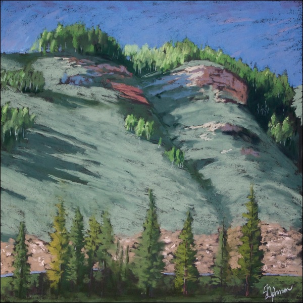
Roadside Cliff Shadows
12x12 inches - black Strathmore

This piece was done in the late afternoon on day one of our trip, a couple of hours after we got back from the first trip to the Lizard Head area.  It's from the campground, from a small meadow near some sites where those huge motorhomes can fit, complete with plenty of space for their satellite dishes...  

My intent was to make it more abstract in terms of colors and shape.   The small stands of aspen on both the top of the cliff and along its slopes were just so appealing (see photo from previous post of the basic view).  Watching the light and shadows change throughout the day on these cliffs and the dividing ravine was so interesting to me.  That, and the presence of both warm and cool shadows on the exposed sedimentary rock, which I believe is Cretaceous period Dakota sandstone.  

I didn't finish the bottom 1/4 of the painting on site, so yesterday, I sat down and tried to resolve it a bit.  I decided to add the road to perhaps help explain the abrupt cut into the cliff.  The roadcut area looks just as unpleasing and out of place in my painting as it does in life, so I guess maybe I shouldn't harsh on it too much.  

At any rate, it was just pleasant to sit in the shade of some large trees and paint it.  Wayne brought out his chair, book and a beer and joined me.  The mosquitos brought their A-game, but are no match against loose, full length sleeves and pants.  

Now, that that the token artwork is out of the way, I can share some of my not-so-secret photography obsessions:  panoramas, or "panos" for short.   Shooting panos can be addictive, and with the advent of high-tech stitching software like the Double Take program I use, it's pretty easy and fun.  Use of manual settings on the camera and a tripod is ideal for panos, but that is really impractical for me 90% of the time since I never carry a tripod on hikes.  Hand-held shots can work fine with practice.

I actually have two Picasa albums devoted to panoramas:  one for Grand Canyon shots, and the other for everything else; some I've posted to the blog in the past, but most have never been shared.   Have a look.  

First up - a view from the East Fork trail on Monday afternoon [click on the photos to see a larger size]:

San Miguels from East Fork trail
3-part landscape-oriented, hand-held

During our hike, I mused to Wayne about how stunning this would be as a sunrise shot to catch the alpenglow on the snow on the east face of the mountain.  What originally seemed like something only a hard-core photographer would do gradually came to be more doable as I considered it.  The main issue is that, despite my desires to be so, I'm not a morning person.

Nonetheless, we discussed it, and decided to give it a go if we got up early enough and could get motivated to drag out of the warm sleeping bag.  Wayne, bless his heart, is always accommodating to my silly artistic whims, as inconvenient as they may be.  We made it happen...sort of:

San Miguels in Morning Light - 5:50 a.m.
3-part landscape-oriented, tripod-mount

I impressed myself by hiking 3/4 of a mile at 5:40 in the morning just to get some photos, and with my tripod.  Perhaps there is hope for me to be one of those "hard core" photographic types after all.

Here's the alpenglow shot from the trailhead, shot at 5:35 a.m.:


Here is a shot a few minutes later, showing the light hitting the hillside:

Hillside Morning and the San Miguels
2-part tripod-mount

After we packed up our camp and headed out up Hwy 145 to spend the next few hours taking in the scenic beauty of the rest of the San Juan Skyway drive, a stop at Trout Lake was in order:

Morning at Trout Lake
4-part landscape-oriented, hand-held

Notice the golden shimmer across the water?  It's pollen, although I'm not sure of its source.  While these  west-facing mountains generally look better in late afternoon light, this photo isn't so bad.

After a quick stop in Telluride for some coffee (and noting several plein air painters already out painting for the Telluride Plein Air Festival that started the same day), we headed along Hwy 62 towards the Dallas Divide.  This geographic and geological divide separates the volcanic San Juan mountains from the Uncompahgre uplift and plateau to the north and east.  

San Juans along the Dallas Divide
2-part landscape-oriented, hand-held
Mt. Sneffels is the highest peak to the left, at 14,150'.  Telluride is on the other side of the range

Here's another single shot of the Mt. Sneffels range, as seen from famous designer and preppy clothing mogul Ralph Lauren's ranch (Double RL Ranch):

This could have been your view...if you'd come up with the idea to embroidery a polo player logo onto clothing

No more panos, but here are a couple of shots from the remainder of the trip:

Close-up of the Uncompahgre Gorge with the river of the same name located in Ouray.  In the winter, this is used as an ice park by climbers.  Crazy, you say?  I agree.

A view of the valley overlooking the town of Ouray.  Some monsoon-type clouds add to the view.

After leaving Ouray, the road climbs up over Red Mountain Pass, then drops down into the old mining town of Silverton, following Mineral Creek part of the way.  From there, it's back to Durango, heading over Molas Pass, Coal Bank Hill, and through the scenic Animas River valley.  

A truly glorious drive, and sort of the obligatory "must do" trip for visitors to Durango that Disneyworld is to Orlando.  Only this is a far, far better way to spend the day.


Related Posts Plugin for WordPress, Blogger...